
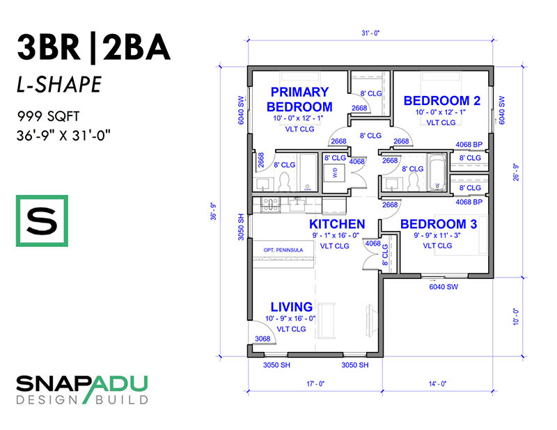
Many homeowners ask if they need to get a survey before proceeding with the planning & permitting process for their accessory dwelling unit (ADU). While you will need a site plan to submit for permits, a boundary survey may or may not be required for ADUs in the County of San Diego, including Oceanside, Carlsbad, Encinitas, San Marcos, Vista and other nearby municipalities. Read on for considerations when you are thinking about if you need a survey for your ADU project.
Do I need a survey for my ADU?
Whether you need a survey for your ADU – and what type of survey – will depend on your jurisdiction requirements, site conditions, location for the ADU and even the building inspector you happen to get for your project.
Over the past few years, you may have been able to get through plan check without a survey. However, many cities are now requiring surveys for all ADU projects (read more on those cases below). Also, some jurisdictions will leave the final decision up to the inspector who, upon visiting the site, may decide a building verification survey is necessary, even if it wasn’t required for an initial building permit. The inspector could then stop the project and require a survey before any work can continue, resulting in delays and unforeseen costs.
At SnapADU, we prioritize thorough planning and budgeting from the outset. To facilitate this, we include a basic planimetric/topographic survey for all our ADU projects. This survey is crucial for accurate planning and budgeting, as it helps to establish a buildable pad for the ADU by assessing the site’s existing conditions and features.
For ADUs positioned close to property boundaries, within 2 feet of a setback, a more detailed survey is typically mandated by the city. This survey is essential to ensure that the ADU is placed correctly, adhering to local zoning and setback requirements. By incorporating these surveys early into our process, we aim to provide homeowners with a clear and predictable path to ADU construction, avoiding potential issues and ensuring compliance with all regulations.
What are the different types of surveys related to planning for an ADU?
Planimetric & Limited Topographic Survey
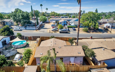
A planimetric survey is an essential initial step in the ADU design and construction process. This survey maps out the existing conditions of your property, including the layout of buildings, trees, driveways, and other significant features. It provides a detailed “bird’s-eye view” of the property, which is crucial for understanding how the land’s contours and features will interact with the proposed ADU, which can significantly affect both the cost and feasibility of the project.
A limited topographic survey goes a step further by providing the vertical elevations of the property. This type of survey is crucial for ADU projects because it reveals the lot’s contours, slopes, and elevation changes, which are vital for foundation design and drainage planning. The “limited” aspect refers to focusing on areas critical for the project at hand, rather than a full topographic survey of the entire property, which might be necessary for larger-scale developments. For an ADU project, this means concentrating on the proposed construction area and its immediate surroundings to ensure that the ADU integrates seamlessly with the existing terrain.
Including a planimetric & limited topographic survey in the feasibility study allows for a more accurate assessment of construction costs and potential site-related challenges. It’s a proactive step that helps avoid costly surprises during construction and ensures that the ADU is designed with a full understanding of the site’s topographical nuances.
Boundary Survey
A Boundary Survey formally locates the property lines of the parcel in question. When building a permanent structure on a property, such as an accessory dwelling unit, it’s essential to ensure that the structure is placed accurately and in compliance with the setbacks. To achieve this, a Boundary Survey is required to determine the location of the property lines, from which the distance of the new structure can be measured.
By completing a Boundary Survey, you’ll have a clear understanding of the property lines, which is critical to ensuring that the ADU is constructed in the correct location and meets all zoning and building code requirements. This survey is a vital step in the ADU building process and helps to ensure a successful and compliant construction project.
Building Verification Survey
A Building Verification Survey (BVS) verifies that the accessory dwelling unit is accurately placed on-site in relation to the property lines and in accordance with the approved plans. The BVS is a follow-up field survey conducted at the installation of the foundation to verify the ADU’s location. In order to complete a BVS, note that a Boundary Survey must first be conducted to locate the property lines.
A Building Verification Survey is a specific requirement that some cities – such as San Marcos and Carlsbad – place on projects that propose a new structure. San Marcos requires building verification surveys in all cases, while Carlsbad requires them when the ADU is within 1′ of a setback. As of October 2022, Oceanside has also started requiring Building Verification Surveys.
TABLE: Survey Scope and Cost Overview for Snap ADU Projects
Survey Type | Purpose | Required? | Cost | Timing |
Planimetric / Limited Topographic Survey | Identifies existing site features for integrating the ADU into the property, crucial for construction documents and cost estimation. | Yes, included in every project | Included in our Feasibility Study (Note: If the project is canceled, a $3,000 fee applies) | During the Feasibility Study. |
Boundary Survey | Determines precise property boundaries, essential for ADU placement and ensuring compliance with property lines. | Case-by-case, based on city requirements and ADU placement | $2,500 – $12,500* | During the Feasibility Study. |
Building Verification Survey | Confirms the ADU’s placement meets setback requirements, typically paired with a Boundary Survey. | Case-by-case, based on city requirements and ADU placement | $2,250 | After foundation forms are set, before pouring concrete. |
Stake Building Corners | Marks the exact location for the new structure, ensuring accurate construction in relation to the site and boundaries. | Yes, included in every project | Included in General Conditions | Prior to or during construction mobilization. |
*Boundary Survey pricing may vary depending on the complexity of the property and the existence of recorded survey monuments in close proximity.
How much does a survey cost?
The cost of a survey will largely be based on the existing surveys and information that are recorded with the county surveyor’s office. In most cases, a boundary & building verification survey would cost between $4,000 – $10,000.
Many other factors can influence cost. For example, if the last survey on record was from 1930 on a parcel 2 blocks away, this would be an expensive survey because the surveyor is effectively starting from scratch and has to map the entire area surrounding the parcel as well, which of course takes significant time. It’s important to get a quote on a survey for your specific property to ensure you know how much it will cost upfront. Your contractor will be able to solicit this quote for you and include in the overall scope of work.
Full grading plans for civil engineering can add thousands more. These plans are required when your site involves a steep slope.
When in the ADU project should a survey be conducted? How long does it take to get a survey?
A survey typically takes 1-2 days to conduct the field observations, and 1-2 weeks to compile and record the findings with the County surveyor’s office. However, surveyors are in high demand and often have a lead time upfront of 2-3 weeks to schedule a survey.
To ensure seamless integration into your project timeline, it is advisable to undertake this survey during the Design phase, allowing the findings to be incorporated into the construction documents. Our established relationships with a network of trusted surveyors enable us to schedule these services with predictability, avoiding unnecessary delays in your project’s progression.
When should I go ahead and get a survey for my ADU?
At SnapADU, we understand the importance of starting your ADU project on solid ground. That’s why we include a planimetric/topographic survey in our initial assessment at no extra charge, ensuring that the startup costs for planning your ADU remain reasonable. However, should you decide to cancel your project before we move forward with construction, a fee of $3,000 for the survey will be applicable.
In some cases, it may be prudent to go ahead with an additional type of survey even though it is not required by the jurisdiction. If you have a challenging lot with a hillside, easements, or other constraints that make design & planning less straightforward, it may be necessary to proceed with a survey. This serves to, again, eliminate the number of surprises you encounter during your ADU build.
If an inspector requires a building verification or boundary survey and you don’t have one, it can stop construction progress and delay the project weeks or even months, and potentially cause a redesign if we have to move the building to account for new setbacks. During this time, you will likely accumulate additional costs as you stop and restart the build process. Overall, putting off a survey usually ends up hurting your build in the long run. Thus, it is well worth your time and money to have your property surveyed early on.
Even if the city never requires a survey, there could be downstream consequences after the ADU is built. A neighbor could bring up a property line issue, force a survey, and potentially find an encroachment. This means you could in theory have to move the building after it has been constructed – not something any homeowner wants to be faced with.
In essence, a survey acts as an insurance policy for your build, providing detailed information about your property and ensuring the ADU is constructed within the proper boundaries. By investing in a survey with SnapADU, you’re not only facilitating a smoother build process but also safeguarding against future disputes, securing peace of mind for the years to come.
I already have a survey… what elements would it need so that SnapADU could use it?
- CAD format and PDF format files are both required.
- Boundary survey accurately plots all property corners and lines that comprise the parcel boundaries.
- Planimetric survey elements accurately plot all current existing site improvements and natural features including but not limited to structures, fences, landscaping, hardscapes, paths, walls etc.
- Topographic survey elements accurately plot all contour lines in 1′ increments showing the current grade elevations across the property in relation to sea level.
- Survey document clearly plots all easements with dimensions in relation to the property lines.
How to use expertise to avoid surprises
The information provided in this blog is based on our extensive experience in design, permitting, and building ADUs, as well as our thorough knowledge of local and state regulations up until now. It’s important to note that regulations may vary in different areas, and local interpretations can differ. We strive to anticipate the most common scenarios and interpretations to provide accurate advice on budget and scope to our clients. Our goal is to ensure that there are no surprises, particularly when it comes to costs and the overall process. However, we do hope that you’ll be pleasantly surprised by how smoothly things go and how amazing your ADU looks upon completion!
0 Comments